Approximate Location Map
Large Map »
Latitude: 51.5258 / 51°31'33"N
Longitude: -3.4891 / 3°29'20"W
OS Eastings: 296790
OS Northings: 181821
OS Grid: SS967818
Mapcode National: GBR HJ.H12R
Mapcode Global: VH5HD.GXS5
Plus Code: 9C3RGGG6+89
Entry Name: Tregroes aka Pencoed College
Listing Date: 4 March 1998
Last Amended: 4 March 1998
Grade: II
Source: Cadw
Source ID: 19475
Building Class: Education
Also known as: Pencoed College
ID on this website: 300019475
Location: Located on the NE side of Pencoed village off the A473. Approached by a sweeping driveway which forms a circle in front (S) of the house. There is a stone wall to the E of the driveway with piers.
County: Bridgend
Community: Pencoed (Pen-coed)
Community: Pencoed
Locality: Tregroes
Traditional County: Glamorgan
Tagged with: Architectural structure Mansion
The seat of the Thomas family, associated with the area from the C16. Said to have been built by Edward Thomas between 1710 and 1730 replacing a house of 1591. The house is shown prominently on Yates’ map of 1799 and also on the Pencoed Tithe Map of 1841. The house was remodelled later C19; rainwater goods bear a date of 1864 and possibly refer to these changes. In 1869 the house passed out of the Thomas family’s ownership. It was purchased by Glamorgan County Council in 1925 and subsequently became a College of Agriculture. The roof was replaced late C20; a photograph from the early C20 shows 2 stacks to the L and R pitch, now missing.
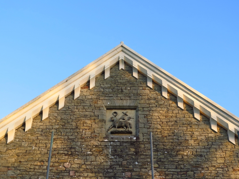
Symmetrical 10-window entrance front with central gable and hipped roof. L-shaped plan, 2 storeys. Coursed masonry with stone dressings, under asbestos-slate roof. Central stack, plus gable stack to rear wing. Pronounced sandstone modillion eaves cornice. The central doorway contains double doors with recessed panels. It is flanked by 5 windows to each side in the upper storey, and 3 windows to each side in the lower storey, beyond which is a pair of French Doors. Symmetrically-placed ornate cast iron, glass roofed veranda to front, supported on 8 columns. In the gable is a recessed sandstone tablet bearing the crest of the Thomas family, the lamb and flag. The window openings have stone sills and flat arched heads with voussoirs. The windows are sashes with margin glazing, the wooden frames of which have decorated heads.
The E front has six x 12-pane sash windows with stone sills and flat arched heads with voussoirs, and 2 late C20 doors. There is a plain 6-column veranda, with a glass or PVCu roof. In the upper storey are 4 irregularly placed sash windows. They are all 12-pane except for one in the centre which has 16 panes. There are 2 small windows to the L to each storey. (A low single storey range, now housing toilets, runs to the E, in alignment with the S front. A 2nd single storey range is to the rear (N) of the wing and may be C20.)
The rear of the house also has 12-pane sash windows with voussoir heads. There are 3 late C20 doors, probably converted from former windows. To the rear of the main range is a stair-light, a stone-dressed and mullioned window with transom, under a relieving arch of voussoirs. The W wall of the main range has a panelled door, with a blocked window to the L and a small window beyond. There is a 12-pane sash to the upper storey. Cast iron rainwater goods bear a date of 1864 and the letter T.
Partial access to the interior the details of which probably date from the 1864 remodelling. The house has a central entrance hall with rear staircase, with rooms leading off to the L and R. The dog-leg staircase has ornate turned balusters and a moulded oak handrail. A segmental archway leads to the stair, and the stair-light to the rear contains stained glass. To the L of the staircase is a large stone fireplace under a moulded 4-centred arch with the lamb and flag crest of the Thomas family. Detail includes ornate plaster coving, dado rails, and panelled doors and shutters.
Listed as an impressive early C18 squire’s house with a strong historical association with Pencoed village. The front, in particular, is almost entirely unaltered since it was remodelled in the later C19.
External links are from the relevant listing authority and, where applicable, Wikidata. Wikidata IDs may be related buildings as well as this specific building. If you want to add or update a link, you will need to do so by editing the Wikidata entry.


Other nearby listed buildings
