History in Structure

Bridge at Tregroes

A Grade II Listed Building in Pencoed, Bridgend

More Photos »
Approximate Location Map
Large Map »

Coordinates

Latitude: 51.5254 / 51°31'31"N

Longitude: -3.4899 / 3°29'23"W

OS Eastings: 296738

OS Northings: 181777

OS Grid: SS967817

Mapcode National: GBR HJ.H0X3

Mapcode Global: VH5HD.GXDG

Plus Code: 9C3RGGG6+53

Entry Name: Bridge at Tregroes

Listing Date: 4 March 1998

Last Amended: 4 March 1998

Grade: II

Source: Cadw

Source ID: 19476

Building Class: Gardens, Parks and Urban Spaces

ID on this website: 300019476

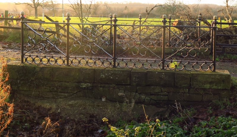
Location: Located on the driveway leading to Tregroes House, just before the drive forms a circle in front of the house. The bridge crosses a small pool or stream which is currently dry.

County: Bridgend

Community: Pencoed (Pen-coed)

Community: Pencoed

Locality: Tregroes

Traditional County: Glamorgan

Tagged with: Bridge Driveway bridge

Find accommodation in
Pencoed

History

The bridge may be early C18 like the house, but the iron railings are probably part of the later C19 remodelling.

Exterior

Low flat-decked bridge of coursed masonry. Round arch with voussoirs, above which is a substantial string course of dressed stone blocks with margin draughting, supporting decorative iron railings. The railings have 4 panels to each side with diagonal struts and a geometrical motif in the centre. The posts have turned finials.

Reasons for Listing

Listed as a decorative garden feature of character which contributes to the architectural setting of Tregroes House.

External Links

External links are from the relevant listing authority and, where applicable, Wikidata. Wikidata IDs may be related buildings as well as this specific building. If you want to add or update a link, you will need to do so by editing the Wikidata entry.

Recommended Books

Other nearby listed buildings

  • II Tregroes aka Pencoed College
    Located on the NE side of Pencoed village off the A473. Approached by a sweeping driveway which forms a circle in front (S) of the house. There is a stone wall to the E of the driveway with piers.
  • II Bridge over Afon Ewenni
    Located off the S side of Penybont Road (B4280), W of a large roundabout at Tregroes, and 0.7km NE of Pencoed. The bridge carries a narrow track to the rear of dwellings along Penybont Road.
  • II Church of St David
    Located on the W side of Penprysg Road to the N of Pencoed County Junior School. The church is situated in a large plot with car park to the S and graveyard to the rear.
  • II War Memorial and Railings
    Located in the centre of Pencoed at the junction of Coychurch Road, Hendre Road and Penybont Road. The GWR and crossing are to the W.
  • II Brynnau Gwynion Overbridge
    To the south west of Brynnau Gwynion, south of the minor road leading to the A473.
  • II Salem Chapel
    Located on the E side of Coychurch Road, 0.4km S of the village centre. The chapel is fronted by low stone walls supporting decorative iron railings, and stone piers. The vestry is to the N and the g
  • II Barn at Bryngwenith
    Situated on low lying ground N of Pencoed, at the end of a short track. The barn forms the E side of the farmyard with a range of masonry and concrete stables extending to the N. The farmhouse is to
  • II Church of SS Ilid and Curig
    An isolated church reached by a track on the S side of a minor road from Pencoed to Llanharry.

BritishListedBuildings.co.uk is an independent online resource and is not associated with any government department. All government data published here is used under licence. Please do not contact BritishListedBuildings.co.uk for any queries related to any individual listed building, planning permission related to listed buildings or the listing process itself.

British Listed Buildings is a Good Stuff website.