Approximate Location Map
Large Map »
Latitude: 52.9189 / 52°55'8"N
Longitude: -4.4943 / 4°29'39"W
OS Eastings: 232397
OS Northings: 338637
OS Grid: SH323386
Mapcode National: GBR 57.N0QS
Mapcode Global: WH448.YW0N
Plus Code: 9C4QWG94+H7
Entry Name: Lodge to N of Plas Boduan
Listing Date: 15 July 1998
Last Amended: 15 July 1998
Grade: II
Source: Cadw
Source ID: 20118
Building Class: Domestic
ID on this website: 300020118
Location: Situated E side of former drive now road running N from Boduan Hall, some 600m NW of the house.
County: Gwynedd
Town: Pwllheli
Community: Buan
Community: Buan
Locality: Boduan
Traditional County: Caernarfonshire
Tagged with: Gatehouse
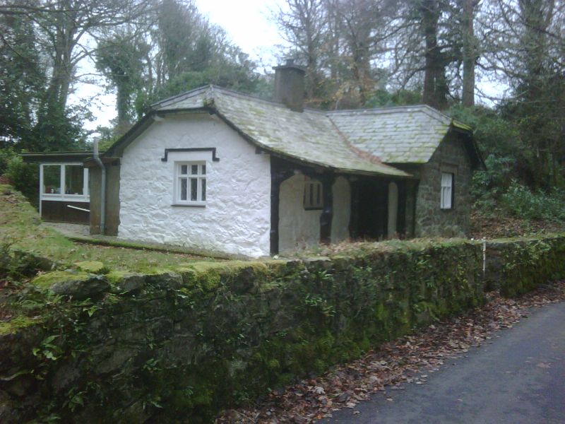
Former Plas Boduan lodge, probably mid to later C19, although an earlier lodge is marked on the 2" OS map of 1816-19. Said to have been the gamekeeper's house.
L-plan single-storey picturesque cottage. Granite rubble-stone walls, partly whitewashed. Slate roofs with half-hipped gables to N and to W end of S crosswing. Overhanging eaves and central rendered chimney. W front has projecting crosswing to right with one 3-light window and hoodmould to end wall and door in N return. Main range has cat-slide roof over 3-bay rustic veranda with tree-trunk uprights and rough 4-centred arcading. Similar window within and another to N end wall. All windows are mullion-and-transom with latticed glazing and flat hoodmoulds. Rear C20 extension.
Included as a good example of a picturesque Victorian estate cottage.
External links are from the relevant listing authority and, where applicable, Wikidata. Wikidata IDs may be related buildings as well as this specific building. If you want to add or update a link, you will need to do so by editing the Wikidata entry.


Other nearby listed buildings
