History in Structure

Pen Uchar Llan

A Grade II Listed Building in Llangernyw, Conwy

More Photos »
Approximate Location Map
Large Map »

Coordinates

Latitude: 53.1922 / 53°11'31"N

Longitude: -3.686 / 3°41'9"W

OS Eastings: 287453

OS Northings: 367451

OS Grid: SH874674

Mapcode National: GBR 68.2YZD

Mapcode Global: WH65S.C103

Plus Code: 9C5R58R7+VJ

Entry Name: Pen Uchar Llan

Listing Date: 17 March 1999

Last Amended: 17 March 1999

Grade: II

Source: Cadw

Source ID: 21475

Building Class: Domestic

ID on this website: 300021475

Location: In the centre of Llangernyw on the S side of the minor road leading W from the village.

County: Conwy

Town: Abergele

Community: Llangernyw

Community: Llangernyw

Traditional County: Denbighshire

Tagged with: Cottage

Find accommodation in
Llangerniew

History

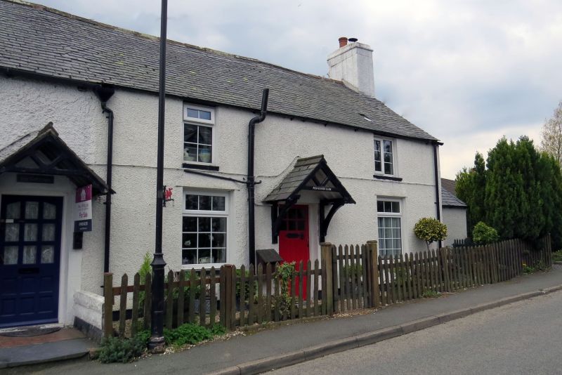
Probably built in the early C19, the building appears on the 1840 Tithe Map in the ownership of Samuel Sandbach of Hafodunos.

Exterior

End of terrace two storey vernacular cottage. Symmetrical front elevation facing N. Central doorway with part glazed timber door. Bracketed timber canopy with gable truss and slate roof above doorway. One bay of windows each side of door; 8/12 cast iron window with fine glazing bars and centre-pivoted top light to first floor E side; remaining windows have late C19 6/6 timber double hung sashes.

Interior

Interior not accessible for inspection at time of resurvey.

Reasons for Listing

Included as part of a row of C19 estate-owned cottages retaining architectural integrity, with features of architectural and historic interest, occupying a prominent location in the village centre, and for group value with St Digain's church and Lychgate.

External Links

External links are from the relevant listing authority and, where applicable, Wikidata. Wikidata IDs may be related buildings as well as this specific building. If you want to add or update a link, you will need to do so by editing the Wikidata entry.

Recommended Books

Other nearby listed buildings

  • II Ivy Cottage
    In the centre of Llangernyw on the S side of the minor road leading W from the village.
  • II Siop Ucha
    In the centre of Llangernyw on the S side of the minor road leading W from the village.
  • II Lychgate to Church of St Digain
    The lychgate is situated on the W side of the churchyard, close to the centre of Llangernyw village.
  • II Raised Slab Monument to Harry Lloyd in churchyard of Church of St Digain
    In th SW section of the churchyard, adjacent to the S wall of the church vestry.
  • II* Church of St Digain
    The parish church stands S of the centre of a roughly oval-shaped churchyard on the S side of Llangernyw village centre. The churchyard is entered through a lychgate at W.
  • II General Store
    The building stands on the W side of the A548, approximately 40m N of the centre of Llangernyw village.
  • II Bryn Coroniad
    The house stands on an elevated site on the N side of the minor road leading W from Llangernyw, approximately 100m W of the village centre.
  • II Llys Alaw
    The house stands on the W side of the A548, approximately 50m N of the centre of Llangernyw village.

BritishListedBuildings.co.uk is an independent online resource and is not associated with any government department. All government data published here is used under licence. Please do not contact BritishListedBuildings.co.uk for any queries related to any individual listed building, planning permission related to listed buildings or the listing process itself.

British Listed Buildings is a Good Stuff website.