Approximate Location Map
Large Map »
Latitude: 51.5711 / 51°34'15"N
Longitude: -3.1117 / 3°6'42"W
OS Eastings: 323050
OS Northings: 186383
OS Grid: ST230863
Mapcode National: GBR J1.D608
Mapcode Global: VH7BB.0ST0
Plus Code: 9C3RHVCQ+C8
Entry Name: 'New Mansion' at Ruperra Home Farm
Listing Date: 13 August 1986
Last Amended: 5 March 1999
Grade: II
Source: Cadw
Source ID: 84994
Building Class: Domestic
ID on this website: 300084994
Location: On open hillside E of Ruperra Home Farm, and reached by a farm road on W side of minor road between Michaelston-y-Fedw and Draethen.
County: Caerphilly
Community: Rudry (Rhydri)
Community: Rudry
Locality: Ruperra
Traditional County: Glamorgan
Tagged with: House
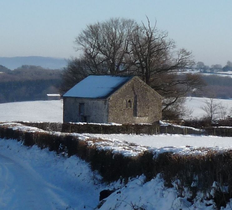
A small late-medieval storeyed house consisting of a first-floor hall and solar, with kitchen and service rooms below. The house was gutted in the C18 to make an agricultural building. The S side faced a yard and had a cattle shed added at its W end, which is now demolished.
Two-storey former house of battered rubble-stone walls and corrugated asbestos-cement roof. The front, facing a former yard, is on the S side and has a wall attached to its L side. A central inserted cow-house doorway is under a timber lintel. To the L is the shadow of a former gabled cattle shed, in which is an inserted doorway with timber surround and lintel. To the R of the central doorway is an added vent strip under a timber lintel, and a doorway under an added concrete lintel further R.
In the R gable end is an external stack cut down below apex and partly corbelled at 1st-floor level. A small blocked window in a (possibly re-used) dressed stone surround and lintel is upper L. The L gable end has a 1st-floor stack (possibly originally on corbels) cut down below apex, to L of which is a 2-light solar window with cusped heads. In the lower storey are blocked windows to former service rooms L and R.
The rear wall has a central cow-house doorway aligned with the front, partly blocked with rubble stone and with an inserted boarded door. To the L of the doorway is a blocked kitchen window with relieving arch. Offset to the L above the central doorway is a boarded loft door under a timber lintel and with brick jambs. A blocked solar window is at upper R.
The plain 4-bay tie-beam roof is C18, after it ceased to be a dwelling. In the R gable end is a segmental-headed kitchen fireplace in the lower storey with an added brick bread oven. In the upper storey is the hall fireplace offset to the L under a timber lintel. Part of a loft survives on cross beams. A ledge in the wall shows that the solar was at a slightly higher level to the L end. In the service rooms below the solar the blocked windows have deep splays.
An important example of a late medieval house retaining early detail despite its conversion for farm use.
External links are from the relevant listing authority and, where applicable, Wikidata. Wikidata IDs may be related buildings as well as this specific building. If you want to add or update a link, you will need to do so by editing the Wikidata entry.


Other nearby listed buildings
