Latitude: 54.9123 / 54°54'44"N
Longitude: -1.3829 / 1°22'58"W
OS Eastings: 439660
OS Northings: 557685
OS Grid: NZ396576
Mapcode National: GBR VCJ.W8
Mapcode Global: WHD55.QSPJ
Plus Code: 9C6WWJ68+WR
Entry Name: Barclay Lodge
Listing Date: 10 November 1978
Last Amended: 17 October 1994
Grade: II
Source: Historic England
Source ID: 1207058
English Heritage Legacy ID: 391388
ID on this website: 101207058
Location: Monkwearmouth, Sunderland, Tyne and Wear, SR6
County: Sunderland
Electoral Ward/Division: St Peter's
Parish: Non Civil Parish
Built-Up Area: Sunderland
Traditional County: Durham
Lieutenancy Area (Ceremonial County): Tyne and Wear
Church of England Parish: Monkwearmouth Team Ministry
Church of England Diocese: Durham
Tagged with: Gatehouse
SUNDERLAND
NZ3957 BARCLAY STREET 920-1/11/13 (South side) 10/11/78 No.58 Barclay Lodge (Formerly Listed as: BARCLAY STREET (South side) No.58 Seacoal House)
GV II
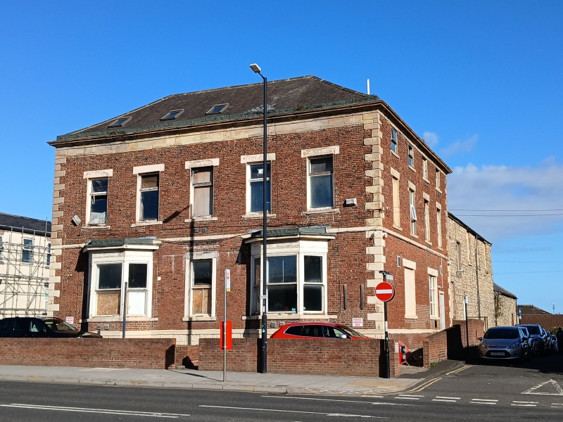
House. c1820. The Shore Inn c1823. 1867 vicarage to Church of St Peter. Hotel at time of survey. Main building Flemish bond brick with painted ashlar plinth, quoins and dressings, and rendered porch sides; left return main building rubble; left additional bay render with brick dressings. Welsh slate roof with brick chimneys. 3 storeys, 3 windows and left addition 2 storeys one window. Right return to North Bridge Street 2 storeys and basement, 5 windows. Rear 3 storeys and 4 windows. U-plan roof. North elevation to Barclay Street has central shallow porch with painted fluted Doric columns supporting plain entablature, sides blocked and rendered; entablature partly obscured by late C20 signboard and sun canopy; internal steps up to renewed glazed door in surrounds with late C20 ceramic tiles. Low plinth; ground, first floor and eaves bands; projecting painted quoins. Sashes with glazing bars have flat stone lintels, except second floor windows under eaves, and projecting stone sills; blind windows in third bay; window to left of door lost glazing bars. Eaves cornice and blocking course. Hipped roof with truncated central ridge chimney. Right return to North Bridge Street with ashlar basement has 5 windows; steps down to basement door, first floor band and deep eaves band; ground floor canted bays flanking central window, all with plain cornices; all windows renewed. Rear elevation has low plinth, floor and eaves bands; door inserted at right; 2 wide ground floor windows, the left blind and the right tripartite with upper glazing bars; upper floors have 4 windows, the two at left blind, renewed casements on first floor and sashes with glazing bars on second floor.
Listing NGR: NZ3966057685
External links are from the relevant listing authority and, where applicable, Wikidata. Wikidata IDs may be related buildings as well as this specific building. If you want to add or update a link, you will need to do so by editing the Wikidata entry.


Other nearby listed buildings