Latitude: 54.9146 / 54°54'52"N
Longitude: -1.3821 / 1°22'55"W
OS Eastings: 439709
OS Northings: 557939
OS Grid: NZ397579
Mapcode National: GBR VCN.FR
Mapcode Global: WHD55.RQ1S
Plus Code: 9C6WWJ79+R5
Entry Name: Wheatsheaf Hotel Public House
Listing Date: 10 November 1978
Last Amended: 17 October 1994
Grade: II
Source: Historic England
Source ID: 1279904
English Heritage Legacy ID: 391556
ID on this website: 101279904
Location: Monkwearmouth, Sunderland, Tyne and Wear, SR6
County: Sunderland
Electoral Ward/Division: St Peter's
Parish: Non Civil Parish
Built-Up Area: Sunderland
Traditional County: Durham
Lieutenancy Area (Ceremonial County): Tyne and Wear
Church of England Parish: Monkwearmouth Team Ministry
Church of England Diocese: Durham
Tagged with: Pub
SUNDERLAND
NZ3957 ROKER AVENUE 920-1/11/178 (South side) 10/11/78 No.207 Wheatsheaf Hotel Public House (Formerly Listed as: ROKER AVENUE (South side) The Wheatsheaf Hotel)
II
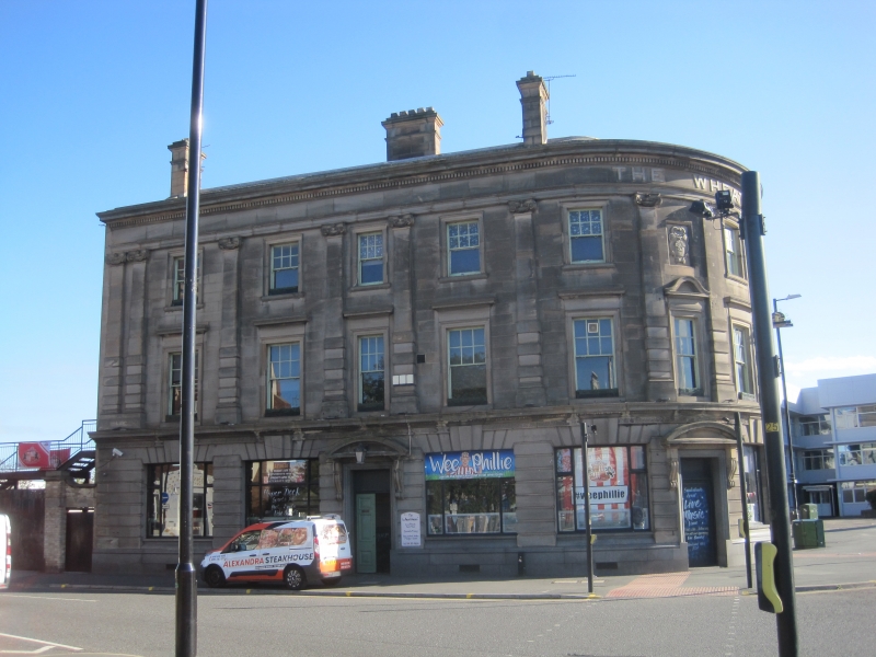
Public house. 1897-8. By S Oswald & Son. For Bell & Taylor. Sandstone ashlar with granite plinth and door architraves; roof of graduated slates with ashlar chimneys. Roughly triangular plan, the W side rounded; classical style. 3 storeys; 4 windows to Roker Avenue, 6 on rounded corner, one wider on Thomas Street North. Rusticated ground floor has doors in 2nd and 6th bays of curved section and in 3rd bay on Roker Avenue; these are 6-panelled, with plain overlights, in granite architraves with scroll brackets supporting segmental pediment hoods. Ground-floor windows are fixed lights with some opening transom lights, and rusticated voussoirs with triple keys rising through frieze to cornice of ground-floor entablature. Upper floors have bays defined by rusticated pilasters with Ionic capitals supporting big dentilled entablature with WHEAT SHEAF HOTEL incised on frieze in well-cut letters. Sash windows have upper glazing bars, in architraves, those on first floor corniced, with ogee pediments to those above doors and in bay between doors on curve; blind bays on second floor above doors in curve have low-relief carved wheatsheaf. Roof has curved hip over curved end; 3 tall corniced ashlar chimneys. An important building at the junction of 6 roads. (Pearson L F: The Northumbrian Pub an Architectural History: Warkworth: 1989-: 98-9).
Listing NGR: NZ3970957939
External links are from the relevant listing authority and, where applicable, Wikidata. Wikidata IDs may be related buildings as well as this specific building. If you want to add or update a link, you will need to do so by editing the Wikidata entry.


Other nearby listed buildings