Latitude: 53.4012 / 53°24'4"N
Longitude: -1.4942 / 1°29'39"W
OS Eastings: 433726
OS Northings: 389490
OS Grid: SK337894
Mapcode National: GBR 9BB.4L
Mapcode Global: WHDDH.0RRZ
Plus Code: 9C5WCG24+F8
Entry Name: Mobilization Store and Squash Court to Former Hillsborough Barracks
Listing Date: 12 December 1995
Grade: II
Source: Historic England
Source ID: 1246522
English Heritage Legacy ID: 455337
ID on this website: 101246522
Location: Hillfoot, Sheffield, South Yorkshire, S6
County: Sheffield
Electoral Ward/Division: Hillsborough
Parish: Non Civil Parish
Built-Up Area: Sheffield
Traditional County: Yorkshire
Lieutenancy Area (Ceremonial County): South Yorkshire
Church of England Parish: Owlerton St John the Baptist
Church of England Diocese: Sheffield
Tagged with: Architectural structure Office building
SK 38 NW SHEFFIELD LANGSETT ROAD
(North East side)
784-1/5/469
Mobilization store and squash
court to former Hillsborough
Barracks
12.12.95
GV II
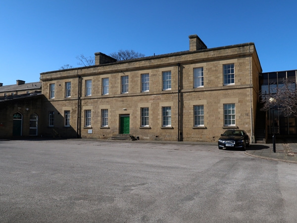
Mobilization store, now offices, and adjoining squash court and retaining wall. 1848-54, used as industrial workshops mid C20, converted 1990. Coursed squared stone with ashlar dressings and hipped slate roof with 2 coped ridge stacks. EXTERIOR: Plinth, first floor sillband, half-round eaves, coped parapets. 2 storeys; 9 window range. Windows mainly unglazed and boarded at time of survey. Recessed centre has 5 windows, and below, central segmental pointed doorway with voussoirs, flanked by 2 windows. Slightly projecting end bays have 2 windows on each floor. INTERIOR: Not inspected. Adjoining roofless racquets court has blank enclosing walls with half-round coping. At the front, a section of curved retaining wall with half-round coping, approx 25m long. HISTORY : Ball courts were common recreational components of nineteenth century barracks. Part of a c9mplete mid C19 barracks. (The Buildings of England: Pevsner N: Yorkshire: The West Riding: London: 1967-: 472; Skeleton record plan of ground floor: 1907 -1923).
Listing NGR: SK3372689490
External links are from the relevant listing authority and, where applicable, Wikidata. Wikidata IDs may be related buildings as well as this specific building. If you want to add or update a link, you will need to do so by editing the Wikidata entry.


Other nearby listed buildings