Approximate Location Map
Large Map »
Latitude: 53.8229 / 53°49'22"N
Longitude: -1.5733 / 1°34'24"W
OS Eastings: 428183
OS Northings: 436374
OS Grid: SE281363
Mapcode National: GBR BB9.ND
Mapcode Global: WHC9C.S5ZN
Plus Code: 9C5WRCFG+5M
Entry Name: Former Coach House and Stables to Wheatfield House
Listing Date: 5 August 1976
Last Amended: 11 September 1996
Grade: II
Source: Historic England
Source ID: 1255682
English Heritage Legacy ID: 465764
ID on this website: 101255682
Location: Far Headingley, Leeds, West Yorkshire, LS6
County: Leeds
Electoral Ward/Division: Headingley
Parish: Non Civil Parish
Built-Up Area: Leeds
Traditional County: Yorkshire
Lieutenancy Area (Ceremonial County): West Yorkshire
Church of England Parish: Headingley St Michael
Church of England Diocese: Leeds
Tagged with: Carriage house
LEEDS
SE2836SW WOOD LANE, Headingley
714-1/62/830 (North side (off))
05/08/76 Former coach house and stables to
Wheatfield House
(Formerly Listed as:
WOOD LANE, Headingley
Former stables (now kitchens)
immediately to west of Wheatfield
House)
GV II
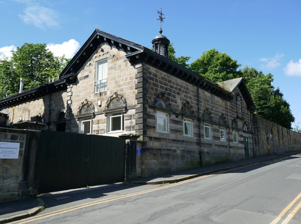
Coach house and stables, now part of hospice premises. c1855,
altered C20. Coursed squared hammer-dressed gritstone and
ashlar, slate roof.
2 storeys over basement, 4-bay asymmetrical main S-facing
facade. Rusticated quoins. Carriage arch left, now blocked, in
Gibbs surround with horse's head carved on the keyblock,
flanking Tuscan columns support broken scrolled pediment with
pulvinated frieze above eaves; 2 windows centre in corniced
and round-arched architrave, the upper part of the windows
blocked and lower frames replaced; slightly projecting gabled
bay right with inserted windows, deep bracketed eaves; wooden
cupola with Ionic columns supporting dome surmounted by
wind-vane to ridge. An ashlar band at cornice level and bands
of rock-facaded rustication below is continued on other
facades.
Rear (to Alma Road): 6 windows, inserted doorway right with a
blind rusticated arch under a gable above. Fenestration as
front but the semicircular traceried overlights remain;
inserted C20 dormers to roof.
Right return: 5 windows with gable far right; steps down to
basement entrance screened by retaining wall with ball finial;
inserted doorways to ground and upper floors.
INTERIOR: not inspected in detail but fittings removed when
the building was converted to kitchen and freezer store; the
building not in use at time of survey.
Listing NGR: SE2818336374
External links are from the relevant listing authority and, where applicable, Wikidata. Wikidata IDs may be related buildings as well as this specific building. If you want to add or update a link, you will need to do so by editing the Wikidata entry.


Other nearby listed buildings
