Latitude: 52.2025 / 52°12'9"N
Longitude: -2.2263 / 2°13'34"W
OS Eastings: 384633
OS Northings: 256055
OS Grid: SO846560
Mapcode National: GBR 1FY.V9N
Mapcode Global: VH92M.CWFY
Plus Code: 9C4V6Q3F+2F
Entry Name: Building Adjacent (North Side) to Security House
Listing Date: 1 August 1977
Last Amended: 27 June 2001
Grade: II
Source: Historic England
Source ID: 1359560
English Heritage Legacy ID: 488500
ID on this website: 101359560
Location: Britannia Square, Worcester, Worcestershire, WR1
County: Worcestershire
District: Worcester
Electoral Ward/Division: Arboretum
Parish: Non Civil Parish
Built-Up Area: Worcester
Traditional County: Worcestershire
Lieutenancy Area (Ceremonial County): Worcestershire
Church of England Parish: Worcester St George with St Mary Magdalene
Church of England Diocese: Worcester
Tagged with: Building
WORCESTER
SO8456SE BARBOURNE ROAD
620-1/6/32 (West side)
01/08/77 Building adjacent (north
side) to Security House
(Formerly Listed as:
BARBOURNE ROAD
(West side)
Building adjacent to
Spreckley (Witco) House)
GV II
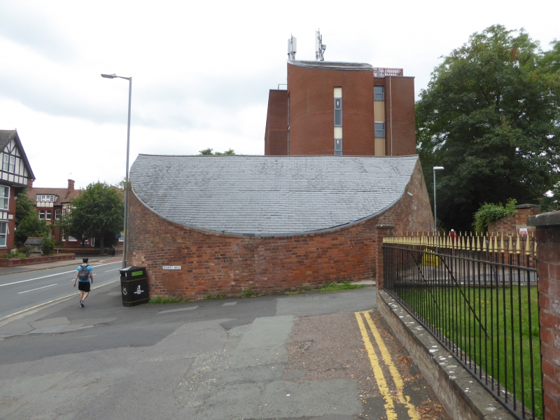
Possibly a horse engine house. c1850, with probable
earlier(c1830) origins, and later alterations and additions.
Reddish-brown brick in Flemish bond with pitched slate roof.
Cast-iron supporting columns. Cast-iron framed window. Approx.
semi-circular in plan. Single-storey with South entrance. Each
gable end has a ventilation eye; Barbourne Road (East)
elevation has fixed multi-pane window, centre four panes pivot
on horizontal axis; segmental arch over and flush brick sill.
Roof ridge runs East-West. The wall-plate to the South
elevation is supported on 2cast-iron columns and later brick
infill. C20 vertically boarded folding doors (6 leaves) to
centre; half height obscured glazing to each side, 3 fixed
lights to right of door, 12 to left.
INTERIOR: roof supported on 4 cast-iron columns and simple
timber trusses. Blue-brick paved floor.
HISTORICAL NOTE: probably part of former Spreckley's Brewery,
Gwilliam thinks this building housed a horse-driven
water-pump. Line of cut bricks at height of approx. 1.3 metres
suggests building was erected on site boundary wall. Shown
on1886 Ordnance Survey Map as being accessed separately.
Remainder of brewery, with the exception of malting house (now
converted to housing), demolished pre-1973. (Gwilliam HW: Old
Worcester: 1977-: 58).
External links are from the relevant listing authority and, where applicable, Wikidata. Wikidata IDs may be related buildings as well as this specific building. If you want to add or update a link, you will need to do so by editing the Wikidata entry.


Other nearby listed buildings