Latitude: 52.2033 / 52°12'11"N
Longitude: -2.226 / 2°13'33"W
OS Eastings: 384648
OS Northings: 256141
OS Grid: SO846561
Mapcode National: GBR 1FY.VCY
Mapcode Global: VH92M.CWJB
Plus Code: 9C4V6Q3F+8H
Entry Name: 3, St Georges Square
Listing Date: 22 May 1954
Grade: II
Source: Historic England
Source ID: 1390079
English Heritage Legacy ID: 489049
ID on this website: 101390079
Location: Britannia Square, Worcester, Worcestershire, WR1
County: Worcestershire
District: Worcester
Electoral Ward/Division: Arboretum
Parish: Non Civil Parish
Built-Up Area: Worcester
Traditional County: Worcestershire
Lieutenancy Area (Ceremonial County): Worcestershire
Church of England Parish: Worcester St George with St Mary Magdalene
Church of England Diocese: Worcester
Tagged with: Building
WORCESTER
SO8456SE ST GEORGE'S SQUARE
620-1/6/544 (South side)
22/05/54 No.3
GV II
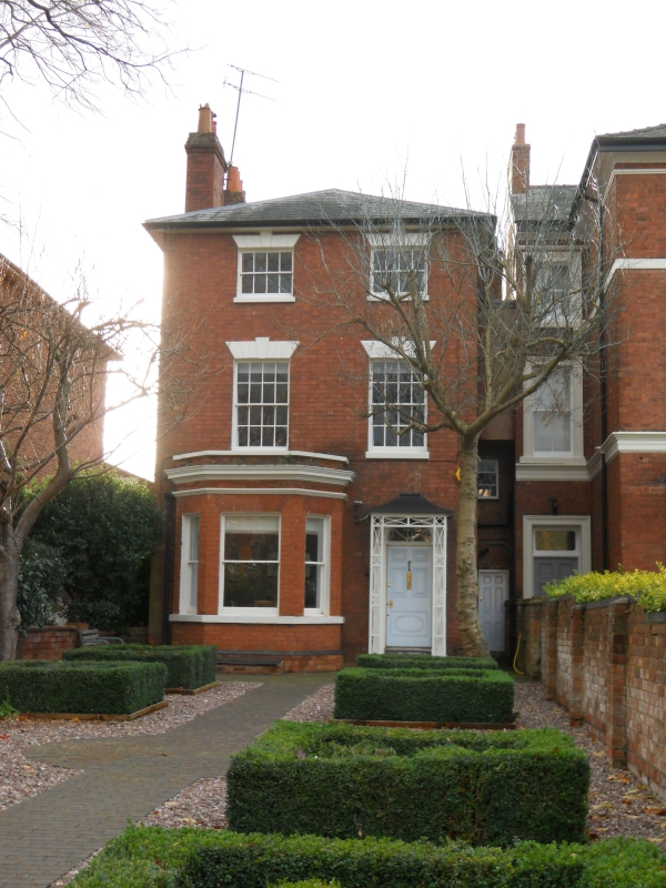
House. c1830-40 with later additions and alterations. Brick
with painted stucco dressings; hipped slate roof; end-wall
(left) stacks with oversailing details and pots; timber porch.
PLAN: double-depth. 2-storey service-range to rear right.
EXTERIOR: 3 storeys. 2 first-floor windows. 8/8 sashes to
first-floor, 4/4 to second-floor, all in plain reveals with
sills and rusticated flat arches with projecting, fluted
keystones. Later canted-bay to left ground-floor with 1/1
sashes, gauged brick flat arches ver; stucco detailing
includes continuous sill, string course, cornice and coping. 2
roll-edged steps to 5-panel entrance door to right, upper
panels raised and fielded, lower panel flush-beaded with
elliptical incised decoration; fanlight with radial glazing
bars, all within moulded architrave. SUBSIDIARY FEATURES:
latticework open-porch with tented roof. NOTE: Of similar
design to No.11 (qv) St. George's Square. (Buildings of
England: Pevsner N: Worcestershire: Harmondsworth: 1968-1985:
334/335).
External links are from the relevant listing authority and, where applicable, Wikidata. Wikidata IDs may be related buildings as well as this specific building. If you want to add or update a link, you will need to do so by editing the Wikidata entry.


Other nearby listed buildings