Approximate Location Map
Large Map »
Latitude: 52.2919 / 52°17'30"N
Longitude: -1.5359 / 1°32'9"W
OS Eastings: 431747
OS Northings: 266070
OS Grid: SP317660
Mapcode National: GBR 6NJ.8HW
Mapcode Global: VHBXJ.BNCF
Plus Code: 9C4W7FR7+PJ
Entry Name: 44, Parade
Listing Date: 30 November 1999
Grade: II
Source: Historic England
Source ID: 1381409
English Heritage Legacy ID: 481770
ID on this website: 101381409
Location: Royal Leamington Spa, Warwick, Warwickshire, CV32
County: Warwickshire
District: Warwick
Civil Parish: Royal Leamington Spa
Built-Up Area: Royal Leamington Spa
Traditional County: Warwickshire
Lieutenancy Area (Ceremonial County): Warwickshire
Church of England Parish: Leamington Spa Holy Trinity
Church of England Diocese: Coventry
Tagged with: Building
ROYAL LEAMINGTON SPA
SP3166SE PARADE
1208-1/2/263 (West side)
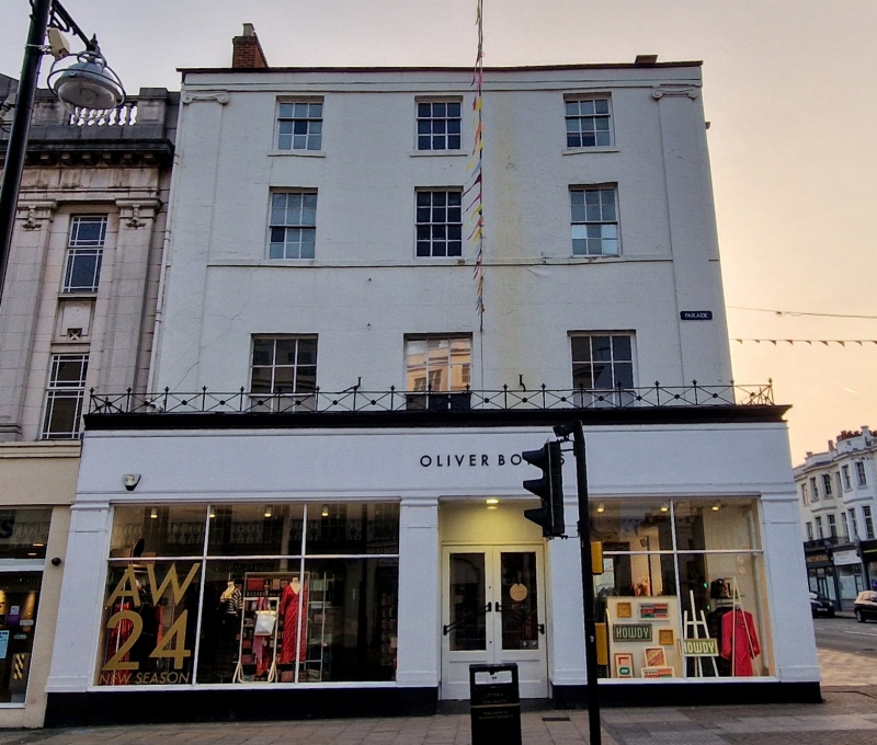
No.44
GV II
House, now shop. c1818-30 with later additions and alterations
including mid-C20 ground-floor shop front.
EXTERIOR: 4 storeys, 3 first-floor windows. Through first,
second and third floors are giant Ionic pilasters to ends.
First floor: tall 6/6 sashes. Second floor: continuous sill
band, 6/6 sashes. Third floor: 3/6 sashes with sills. All in
plain reveals. Frieze, copings. Tall end stacks.
Right return to Warwick Street: round-arched staircase window
a 3/9 sash with radial-glazing to head and with margin-lights,
in plain reveals and with sill. Band to gable.
INTERIOR: openwell staircase from first floor has stick
balusters.
HISTORICAL NOTE: the Parade was so-named in 1860, as Upper
Parade and Lower Parade. Originally Lillington Lane, it was
renamed Union Row c1809 and then Union Parade by 1814 and the
Parade in 1860. The lower section was laid out c1810-1814,
with mast building activity c1810-1818, the upper section,
west side was built 1827-1840. Built as houses, hotels and
lodging-houses, by 1850 most had become shops.
Occupies an important corner site.
Listing NGR: SP3174766070
External links are from the relevant listing authority and, where applicable, Wikidata. Wikidata IDs may be related buildings as well as this specific building. If you want to add or update a link, you will need to do so by editing the Wikidata entry.


Other nearby listed buildings
