Approximate Location Map
Large Map »
Latitude: 53.25 / 53°14'59"N
Longitude: -3.1337 / 3°8'1"W
OS Eastings: 324456
OS Northings: 373149
OS Grid: SJ244731
Mapcode National: GBR 6ZKV.CP
Mapcode Global: WH76S.TKZW
Plus Code: 9C5R6VX8+XG
Entry Name: Town Hall
Listing Date: 5 December 1972
Last Amended: 11 September 1995
Grade: II
Source: Cadw
Source ID: 14891
Building Class: Civil
ID on this website: 300014891
Location: At E end of Church Street; near station.
County: Flintshire
Community: Flint (Y Fflint)
Community: Flint
Built-Up Area: Flint
Traditional County: Flintshire
Tagged with: City hall Seat of local government
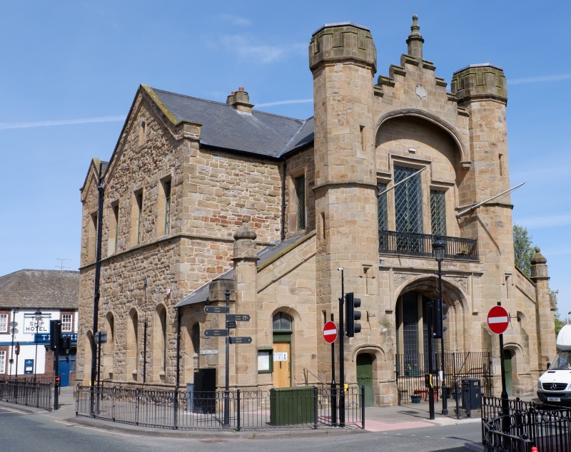
Built 1840, by John Welch, architect, with later alterations. Ground floor formerly market. Original design illustrated in H Taylor, Historic Notices of Flint.
Brown stone, ashlar to SE and NW ends, squared rubble to sides, slate roof, generally casement windows with diamond panes. Two storeys. Entrance (to SE) has flanking octagonal turrets with loops and 3-centred doorways; stepped gable between turrets (which have 3-centred arched doorways) has pinnacle; broad archway overhangs first floor window of 3 lights (central light higher) which gives onto balcony with iron balustrade; former entrance doorway has deep arch. Lean-to wings have 3-centred arched doorways/windows and corner octagonal buttresses; square-headed window to first floor returns (3-centred to ground floor). SW and NE elevations have 2 gables; on ground floors, four 3-centre arched windows or doors. On first floor (railway side) arched window to L, and two windows to R (small attic window above); first floor (town side) has 4 square-headed windows, and small attic window). NW elevation similar to main entrance but with turrets framing attic window (hoodmould), triple first floor window over ground floor arch. Beyond turrets, to each side, 3-centred arched window, small turrets to ends.
Ground floor modernised. First floor retains council chamber with hammer beam roof. Ceiling of Mayor’s parlour has heraldry of Tribes of Wales.
Included as striking example of building type.
External links are from the relevant listing authority and, where applicable, Wikidata. Wikidata IDs may be related buildings as well as this specific building. If you want to add or update a link, you will need to do so by editing the Wikidata entry.


Other nearby listed buildings
