History in Structure

Gravestone of John Ystymllyn

A Grade II Listed Building in Dolbenmaen, Gwynedd

More Photos »
Approximate Location Map
Large Map »

Coordinates

Latitude: 52.9261 / 52°55'33"N

Longitude: -4.1949 / 4°11'41"W

OS Eastings: 252551

OS Northings: 338776

OS Grid: SH525387

Mapcode National: GBR 5M.MMGX

Mapcode Global: WH55K.JQN4

Plus Code: 9C4QWRG4+C2

Entry Name: Gravestone of John Ystymllyn

Listing Date: 30 March 1999

Last Amended: 30 March 1999

Grade: II

Source: Cadw

Source ID: 21528

Building Class: Religious, Ritual and Funerary

ID on this website: 300021528

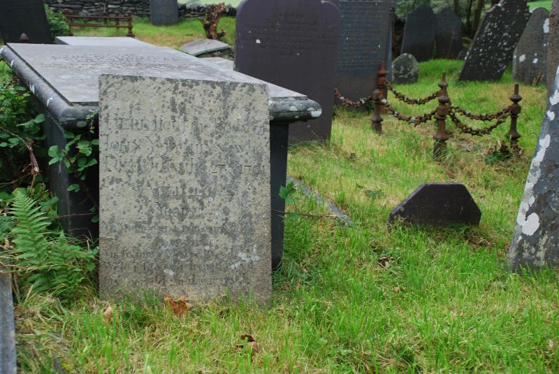
Location: The headstone stands in the churchyard of the church of St Cynhaearn, on the N side of the path from the lychgate.

County: Gwynedd

Town: Dolbenmaen

Community: Dolbenmaen

Community: Dolbenmaen

Locality: Ystumllyn

Traditional County: Caernarfonshire

Tagged with: Grave

Find accommodation in
Criccieth

History

John Ystymllyn, colloquially known as Jac Black, was captured in the Indies in 1742 by a member of the Wynn family and brought back to Wales, and who did service at the nearby farm of Ystymllyn, from where he took his name. He is said to be the first slave brought into N Wales. A portrait of him is held by Ronald Armstrong Jones, Plas Dinas.

Exterior

A simple sandstone headstone, elegantly inscribed with the inscription 'Here lieth the Body of John Ystymllyn who Died July the 27th 1791, Aged 46 Years, followed by an inscription recording his origin in India (probably the West Indies).

Reasons for Listing

Included as of special interest in commemorating a slave in service in Wales in the later years of the C18, who must have been well enough thought of that he was provided with a handsome memorial.

External Links

External links are from the relevant listing authority and, where applicable, Wikidata. Wikidata IDs may be related buildings as well as this specific building. If you want to add or update a link, you will need to do so by editing the Wikidata entry.

Recommended Books

Other nearby listed buildings

  • II Lychgate to the Church of St Cynhaearn
    St Cynhaearn stands isolated approximately 900m S of Pentrefelin village. The lychgate stands in front of the churchyard wall and provides the entrance to the rectangular churchyard from the SW.
  • II Tomb of David Owen
    The tomb is located in the churchyard of the Church of St Cynhaearn, set at the W end against the SE boundary wall.
  • II Monuments to John Williams and Ellis Owen
    The two monuments stand immediately outside the W door of St Cynhaearn's church, on the right side of the path to the lychgate.
  • II Carreg and Pilkington Tombs
    The two railed tombs are close to the S side of the nave of the Church of St Cynhaearn.
  • II* Church of St Cynhaearn
    The church stands alone on the former island in Llyn Ystumllyn, approx 900m S of Pentrefelin, and is reached by a track from the village.
  • II* Former Stables
    Set back from the road 2km approx, to the E of the town, and 0.5km approx. Down a track.
  • II* Ystumllyn
    Set back from the road 2km approx, to the E of the town, and 0.5km approx. Down a track.
  • II* Wash House
    Set back from the road 2km approx, to the E of the town, and 0.5km approx. Down a track.

BritishListedBuildings.co.uk is an independent online resource and is not associated with any government department. All government data published here is used under licence. Please do not contact BritishListedBuildings.co.uk for any queries related to any individual listed building, planning permission related to listed buildings or the listing process itself.

British Listed Buildings is a Good Stuff website.