Latitude: 52.926 / 52°55'33"N
Longitude: -4.195 / 4°11'42"W
OS Eastings: 252542
OS Northings: 338768
OS Grid: SH525387
Mapcode National: GBR 5M.MMFV
Mapcode Global: WH55K.JQL6
Plus Code: 9C4QWRG3+CX
Entry Name: Lychgate to the Church of St Cynhaearn
Listing Date: 19 October 1971
Last Amended: 30 March 1999
Grade: II
Source: Cadw
Source ID: 21547
Building Class: Religious, Ritual and Funerary
ID on this website: 300021547
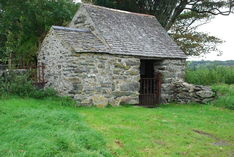
Location: St Cynhaearn stands isolated approximately 900m S of Pentrefelin village. The lychgate stands in front of the churchyard wall and provides the entrance to the rectangular churchyard from the SW.
County: Gwynedd
Town: Dolbenmaen
Community: Dolbenmaen
Community: Dolbenmaen
Locality: Ystumllyn
Traditional County: Caernarfonshire
Tagged with: Lychgate
The lychgate was probably erected in the C18 to provide shelter at the entrance to the graveyard.
Built of rubble stonework flushed with mortar, with an old irregular sized slate roof. A gated stile stands at the side of the stone-built storeroom added on its W side. Openings on each face of the lychgate have slate lintels, and the gable walls are returned to enclose the ends of stone benches internally each side. Pine roof, with slates fully torched, and single tier of purlins. Cast iron gate. The building is extended to the SW by a churchyard store with a lower pitched old slate roof.
Fixed to the internal walls of the lychgate are C18 slate headstones, including WK 1728; Jane Daniel 1761; Thomas Rowland, 1757 and Jane Jones, 1776.
Included as a simple C18 lychgate having a vernacular character, of group value with the Church of St Cynhaearn.
External links are from the relevant listing authority and, where applicable, Wikidata. Wikidata IDs may be related buildings as well as this specific building. If you want to add or update a link, you will need to do so by editing the Wikidata entry.


Other nearby listed buildings