Approximate Location Map
Large Map »
Latitude: 52.3364 / 52°20'11"N
Longitude: -2.2792 / 2°16'45"W
OS Eastings: 381069
OS Northings: 270962
OS Grid: SO810709
Mapcode National: GBR 0C0.DL5
Mapcode Global: VH920.FJXR
Plus Code: 9C4V8PPC+H8
Entry Name: 5, 6 and 7, Severnside
Listing Date: 9 November 1971
Last Amended: 11 October 1991
Grade: II
Source: Historic England
Source ID: 1292611
English Heritage Legacy ID: 393387
ID on this website: 101292611
Location: Stourport-on-Severn, Wyre Forest, Worcestershire, DY13
County: Worcestershire
District: Wyre Forest
Civil Parish: Stourport-on-Severn
Built-Up Area: Stourport-on-Severn
Traditional County: Worcestershire
Lieutenancy Area (Ceremonial County): Worcestershire
Church of England Parish: Stourport-on-Severn and Wilden
Church of England Diocese: Worcester
Tagged with: Building
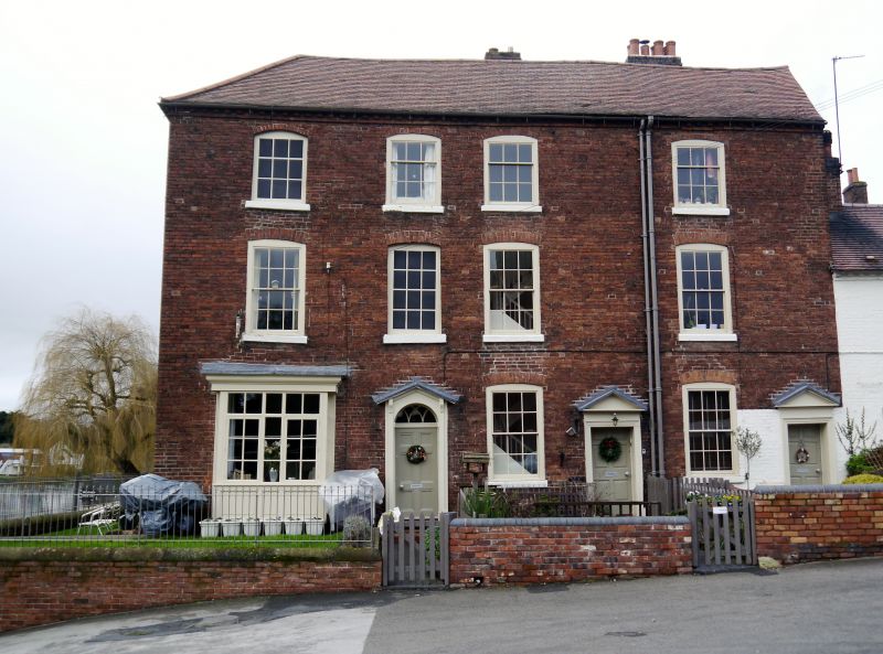
STOURPORT ON SEVERN
SO8170NW SEVERNSIDE
589-1/13/70 (North side)
09/11/71 Nos.5, 6 AND 7
(Formerly Listed as:
SEVERN SIDE
Nos.4-7 (Consecutive))
GV II
Terrace of 3 houses. Late C18. Brick with hipped plain tiled
roof. 3-storeyed, each dwelling a single-unit plan but
additional windows over doorway of No.5 create 4 unequally
sized bays in upper storeys. 6-panelled doors with traceried
overlights in pedimented cases, carried on console brackets,
and with some variation in the extent of the detailing.
Windows are 2-light casements with transoms and segmentally
arched brick heads. One inserted window to ground-floor left.
Dentilled eaves band throughout and axial stacks to rear.
Gable end facing river has inserted windows on ground and
first floor, replacing former Palladian windows. 2 hipped
roofed wings to rear.
Listing NGR: SO8106670963
External links are from the relevant listing authority and, where applicable, Wikidata. Wikidata IDs may be related buildings as well as this specific building. If you want to add or update a link, you will need to do so by editing the Wikidata entry.


Other nearby listed buildings
