History in Structure

Circular Pigsty at the Meadows

A Grade II Listed Building in Llancarfan, Vale of Glamorgan

More Photos »
Approximate Location Map
Large Map »

Coordinates

Latitude: 51.4426 / 51°26'33"N

Longitude: -3.3845 / 3°23'4"W

OS Eastings: 303875

OS Northings: 172419

OS Grid: ST038724

Mapcode National: GBR HN.N9DZ

Mapcode Global: VH6FH.904F

Plus Code: 9C3RCJV8+26

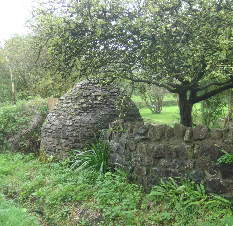
Entry Name: Circular Pigsty at the Meadows

Listing Date: 8 September 1995

Last Amended: 8 September 1995

Grade: II

Source: Cadw

Source ID: 16412

Building Class: Agriculture and Subsistence

ID on this website: 300016412

Location: Located on the S side of the road junction, opposite Tre-Aubrey house.

County: Vale of Glamorgan

Community: Llancarfan

Community: Llancarfan

Locality: Tre-Aubrey

Traditional County: Glamorgan

Tagged with: Pigsty

Find accommodation in
Llancarfan

Exterior

Traditional C18 corbelled pigsty constructed of coursed liassic limestone rubble with traces of limewash together with the remains of the pig pen with enclosing walls, also of limestone. The stone stile survives in the wall to the N of the sty.

Reasons for Listing

Listed grade II as a good surviving example of this scarce building type.

External Links

External links are from the relevant listing authority and, where applicable, Wikidata. Wikidata IDs may be related buildings as well as this specific building. If you want to add or update a link, you will need to do so by editing the Wikidata entry.

Recommended Books

Other nearby listed buildings

  • II Ty-draw Farmhouse
    About 1.2km west of Llantrithyd Church to S of minor road between Llantrithyd and St Hilary. Entrance faces south.
  • II Ruins of Llantrithyd Place
    Located SW of the churchyard of Llantrithyd parish church, fronting the Nant Llantrithyd to the SW.
  • II Agricultural Range at Ty-draw Farm
    To W of Ty Draw Farmhouse, which is about 1.2km E of Llantrithyd Church, on minor road between Llantrithyd and St Hilary.
  • II Telephone Call-box to N of parish Church
    At the roadside close to the boundary wall along the N side of the churchyard St Illtyd's parish church.
  • II* St Illtyd's Parish Church
    Located at the centre of the Village, W of Llantrithyd Place.
  • II* Treguff Farmhouse
    Set on high ground, on a platform site, E of the Nant Treguff and 2km NW of Llancarfan. Large farmyard below. Stone stile to front courtyard which has rubble boundary wall.
  • II Garehouse at Llanfythin Farmhouse
    Located to the N of Llancarfan village located on a private lane leading W from the Llancarfan- Bonvilston Road, immediately in front of Llanfythin Farmhouse.
  • II Llanfythin Farmhouse
    Farmhouse set on the W side of the Nant Llancarfan valley 1km due N of the village of Llancarfan.

BritishListedBuildings.co.uk is an independent online resource and is not associated with any government department. All government data published here is used under licence. Please do not contact BritishListedBuildings.co.uk for any queries related to any individual listed building, planning permission related to listed buildings or the listing process itself.

British Listed Buildings is a Good Stuff website.