Approximate Location Map
Large Map »
Latitude: 52.2647 / 52°15'53"N
Longitude: -1.7691 / 1°46'8"W
OS Eastings: 415854
OS Northings: 262976
OS Grid: SP158629
Mapcode National: GBR 4KR.X52
Mapcode Global: VHB04.9B3Q
Plus Code: 9C4W767J+V9
Entry Name: Wootton Wawen Aqueduct
Listing Date: 4 January 1990
Grade: II*
Source: Historic England
Source ID: 1382221
English Heritage Legacy ID: 482587
Also known as: Aqueduct
ID on this website: 101382221
Location: Wootton Wawen, Stratford-on-Avon, Warwickshire, B95
County: Warwickshire
District: Stratford-on-Avon
Civil Parish: Wootton Wawen
Traditional County: Warwickshire
Lieutenancy Area (Ceremonial County): Warwickshire
Church of England Parish: Wootton Wawen St Peter
Church of England Diocese: Coventry
Tagged with: Aqueduct
WOOTTON WAWEN
SP16SE SOUTH STRATFORD CANAL
1457-1/5/155 Wootton Wawen Aqueduct
04/01/90
II*
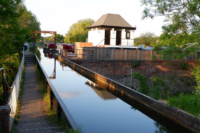
Aqueduct. 1813 with later additions and restorations of 1960.
By William Whitmore for the Stratford Canal Company. Cast-iron
trough with integral towpath with cast-iron railings to north,
brick piers and retaining walls in English bond with ashlar
copings.
Railings have stick balusters and moulded handrail and
brackets. All carried on 3 piers, those 2 to east are splayed,
that to west restored.
South side of aqueduct has an attached oval plate with
inscription: `This Aqueduct was erected by The Stratford Canal
company in October 1813, Bernard Dewes Esqr Chairman, W James
Esqr Dept Chairman, W Whitmore Engineer.' Crosses Stratford
Road, A34.
The Southern Stratford Canal was constructed between 1793-1816
at a cost of »500,000. 13.5 miles of the canal from Kingswood
Junction, Lapworth to Stratford-upon-Avon was leased by the
National Trust in 1960 from the British Waterways Board for
restoration. The National Trust acquired the freehold c1964.
Wootton Wawen Aqueduct is a Scheduled Ancient Monument, County
number 132.
Listing NGR: SP1585462976
External links are from the relevant listing authority and, where applicable, Wikidata. Wikidata IDs may be related buildings as well as this specific building. If you want to add or update a link, you will need to do so by editing the Wikidata entry.


Other nearby listed buildings
